FishMap
 |
Integrated spatio-temporal models combining fisheries and research surveys fine scale catch data to estimate functional zones |
|
Research
Context and Issues
There is an increasing need for high resolution seasonal mapping in order to move towards the spatial planning of marine uses and the conservation of important biological areas (reproduction areas, nursery areas….) called fishery functional zones.Research surveys, usually conducted yearly collect precise information on fish biology (species identification, abundance, maturity…). However, most of the surveys occur once or twice a year and sampling effort generally only has a poor spatio-temporal density. As a consequence survey data cannot be used to infer intra-annual variability. The recent development of Vessel Monitoring System (VMS) provides the opportunity to fill this gap. VMS data consist in fishery data of high spatial and temporal resolution. Coupling these data with landings and observer data (at sea or onshore sampling) would provide a fine description of catches per species and size classes. However, commercial catch data can suffer from a major drawback: as fishers tend to target zones of higher abundance (a process referred to as preferential sampling), commercial data do not reach classical random sampling conditions. Ignoring this process may result in overestimation of abundance where sampling is low and then in overestimation of abundance integrated over the entire area of interest. Integrating commercial data in the model hence requires preferential sampling to be explicitly considered.
Objectives
The project seeks to develop species distribution models at a fine spatio-temporal scale, through the integration of multiple sources of data within integrated hierarchical spatio-temporal models. Results will allow to answer the following questions:
- How do the integration of commercial data improve estimates of fish distribution?
- What are the characteristics of the fisheries functional zones, their variability in time and the ecological consequences of their variations?
- What is the spatio-temporal dynamic of the different métiers interacting with this fish resource?
Methodology
We develop spatio-temporal hierarchical models to infer a spatial field of species distribution from multiple sources of data. The models integrate scientific survey data and commercial data by explicitly considering preferential sampling for commercial data. Spatial distribution of abundance is modelled as a latent spatial random field. Statistical inferences largely rely on Stochastic Partial differential Equations (SPDE) methods as implemented in TMB or INLA R-packages.The methodological framework will be applied to different case studies of demersal and pelagic fisheries.
Expected Results
- An integrated spatio-temporal modeling framework to infer species distribution from the integration of scientific survey and commercial data
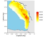
- Fishery functionnal zones for different species (sole, sardine, hake …)
- New insights on the relationship between the spatial distribution of fishes and fishermen behavior
Publications issued from the project
People involved
 |
ALGLAVE Baptiste, Ph.D. Student |
 |
RIVOT Etienne, Scientist Phone : +33 2 23 48 59 34 Email : etienne.rivot@institut-agro.fr |
Partners
Youen Vermard, Ifremer Nantes EMH
Mathieu Woillez, Ifremer Brest LBH
Marie-Pierre Etienne, Institut Agro, Département Mathématique et Informatique
NOAA North West Fishery center, Seattle, USA
DTU Aqua, Copenhaguen, Danemark
Funding and Support
Ifremer - Union Européenne (DG Mare)